Molly O'Neill nature track
Bungonia National Park
Overview
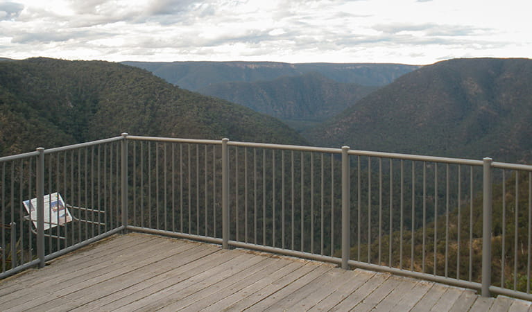
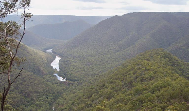
Enjoy this easy walk along Molly O’Neill nature track which passes through open woodland, teeming with wildlife, takes in limestone outcrops, and ends at Bungonia lookdown.
- Where
- Bungonia National Park in Country NSW
- Accessibility
- Medium
- Distance
- 0.3km one-way
- Time suggested
- 15 - 45min
- Grade
- Grade 2
- Entry fees
- Park entry fees apply
- What to
bring - Drinking water, hat, sunscreen
- Please note
- On entering the park, register your trip intention at the park office visitor register.
- The weather in this area can be extreme and unpredictable, so please ensure you’re well-prepared for your visit.
- Remember to take your binoculars if you want to birdwatch.
Molly O’Neill was an amateur botanist who passionately dedicated herself to exploring and researching what was, at the time, Bungonia Reserve and is now Bungonia National Park. It is only fitting, therefore, that a walking track has been named in her honour.
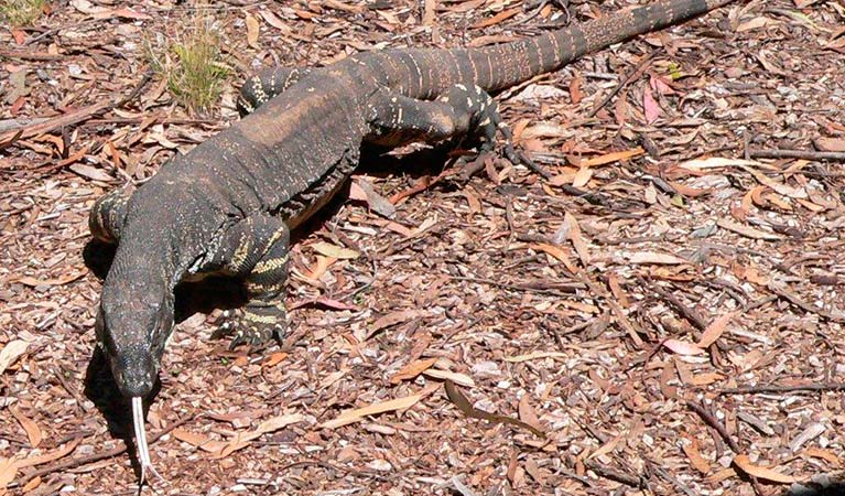
Take your time along this short track to read the interpretive signage and see what you can learn about some of the plants native to the park. Enjoy the wildflowers during spring and keep your binoculars handy to look at the wildlife whose habitats you’re passing through. During daylight hours, you’re most likely to see wallaroos, wallabies, kangaroos, goannas and lyrebirds. At night, you may get a glimpse of a glider and you will almost certainly see possums.
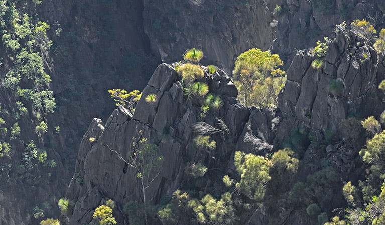
The track passes through the park’s typical eucalyptus woodland with limestone outcrops and ends, with a flourish at The Lookdown lookout. For a longer hike try the Green track.
Map
Map legend

Local alerts
For the latest updates on fires, closures and other alerts in this area, see https://www.nationalparks.nsw.gov.au/things-to-do/walking-tracks/molly-oneill-nature-track/local-alerts
General enquiries
- National Parks Contact Centre
- 7am to 7pm daily
- 1300 072 757 (13000 PARKS) for the cost of a local call within Australia excluding mobiles
- parks.info@environment.nsw.gov.au
Park info
- in Bungonia National Park in the Country NSW region
Bungonia National Park is always open but may have to close at times due to high fire danger, or park operations. It's a good idea to ring the office for current information.
-
Park entry fees:
$8 per vehicle per day. Daily fees can be paid at the ticket machines at the park office.
Buy annual pass.
Visitor info
All the practical information you need to know about Molly O'Neill nature track.
Track grading
Features of this track
Distance
0.3km one-way
Time
15 - 45min
Quality of markings
Clearly sign posted
Experience required
No experience required
Gradient
Flat
Quality of path
Formed track: From David Reid carpark, the first 250m of the track is a flat gravel path. Wheelchair users and people with reduced mobility may need assistance along the gravel surface.
The last 50m of the track is a concrete path that leads to a timber boardwalk lookout.
Steps
Occasional steps: There are no steps along this walk, but there are 20 timber steps without handrails on the detour that leads to Lyrebird's Lair Cave.
Other barriers
Pinch points: There are no significant pinch points along the walk, but there may be sections where rocks or plants cause the track to narrow slightly.
Getting there and parking
Get driving directions
Molly O’Neill nature track is in the northern precinct of Bungonia National Park. To get there:
- From Bungonia follow Lookdown Road to the park entrance
- Drive past the park office and continue along Lookdown Road until you reach David Reid carpark.
Alternatively, the walk can also be started from The Lookdown lookout.
Parking
There's parking where the walk begins at bitumen David Reid carpark, including 1 designated accessible parking spot.
There's also a smaller bitumen carpark near The Lookdown lookout if you'd like to start the track from there instead. It has 1 designated accessible parking spot.
Best times to visit
There are lots of great things waiting for you in Bungonia National Park. Here are some of the highlights.
Autumn
After the heat of summer has subsided, take advantage of the milder weather for hiking in the park.
Spring
Enjoy bushwalking in the comfortable temperatures of this time of year when the wildflowers are at their finest. Late in the season, the stands of brittle gum become extremely photogenic as their white trunks turn pink.
Winter
Deeper exploration of caves is possible when their carbon dioxide levels reduce in winter as the warm air from within rises and the caves ‘breathe'.
Weather, temperature and rainfall
Summer temperature
Average
12°C and 26°C
Highest recorded
40°C
Winter temperature
Average
1°C and 13°C
Lowest recorded
-9°C
Rainfall
Wettest month
March
Driest month
September
The area’s highest recorded rainfall in one day
200.7mm
Facilities
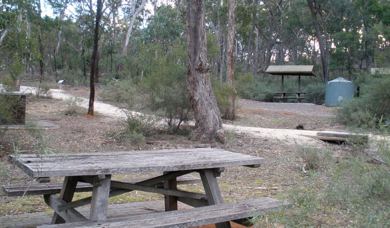
- Facilities, including accessible toilets, picnic tables and barbecues, are available at David Reid carpark.
- There is limited water available in this area, so it’s a good idea to bring your own.
Seats and resting points
There's a seat with a backrest at the northern end of the track near The Lookdown lookout. There are also picnic tables where you can rest at the southern end of the track, near David Reid carpark.
Maps and downloads
Accessibility
Disability access level - medium
- The first 250m of this track is a flat gravel path that winds through eucalypt forest.
- Some assistance may be required for wheelchairs and visitors with limited mobility, as you make your way along the gravel surface.
- The last 50m of track is a concrete path that leads to a timber boardwalk lookout with railings.
- There are picnic tables and accessible toilets with a concrete path leading to them at David Reid carpark, at the start of the track.
- If you prefer to avoid the gravel walk, you can park at Bungonia Lookdown carpark and take the concrete path to the lookout.
Medium access presents some minor difficulties, such as a grassy surface. You may require a little assistance to get around in some areas.
Prohibited
Pets
Pets and domestic animals (other than certified assistance animals) are not permitted. Find out which regional parks allow dog walking and see the pets in parks policy for more information.
Smoking
NSW national parks are no smoking areas.
Learn more
Molly O'Neill nature track is in Bungonia National Park. Here are just some of the reasons why this park is special:
Endless caving opportunities
Known as the adventure capital of the Southern Tablelands, Bungonia is a place to really test your limits. There are around 200 wild caves in the park, many of which are open for experienced cavers to explore. For an exciting journey of waterfalls and plunge pools, Bungonia Creek and Jerrara Creek are the most popular canyoning spots. Bungonia Slot Canyon provides one of the few opportunities in Australia for climbing limestone and is as dramatic a place to scale a rock wall as its name suggests.
- De Kerrilleau picnic area Bungonia National Park, in easy reach of Canberra, is an outdoor adventure playground offering caving, canyoning, rock climbing, abseiling, hiking and impressive views.
- The Lookdown lookout It’s an easy walk from the carpark at the end of Lookdown Road to Bungonia lookdown, which offers superb scenic views into Bungonia Creek Gorge and beyond.
Once upon a time
The park lies across the traditional lands of the Njunawal tribal group, the northwest corner of the Wandandian tribal territory and the southern boundary of the Gandangara tribal group. The ridge tops were almost certainly travel routes as people shifted in accordance with the seasonal availability of food. Evidence of campsites exists on the main plateau and limestone dolines contain edible plants consumed or used by Aboriginal people.
One of our oldest parks
This park is one of the oldest in New South Wales. It was first protected as a water reserve in 1872, which was also the same year the world's first national park - Yellowstone, in USA - was established. Just as Yellowstone's geothermal features pull the crowds, Bungonia's geomorphology, both above and belowground, are its main draw. Louis Guymer was the park's first caretaker (1889-1909), who discovered caves and erected gates and ladders, some of which you may use during your visit.
- Bungonia Gorge guided adventure treks Go on a day hike or weekend trek to Bungonia Gorge with 100% Adventure. It’s a great way to experience Bungonia National Park, the adventure capital of the Southern Tablelands.
Winged and furry
The vulnerable large bent-wing bat calls Bungonia home, and certain caves are closed during the year to help provide a safe environment for breeding and hibernation. When open, look out for a colony, cloud or cauldron of bats as you explore the limestone labyrinths of their natural habitat. A small population of koalas, classified as threatened, also inhabit the park.
- Adams lookout Adams lookout, great for birdwatching and picnicking, is the only platform in Bungonia that offers a view of the magnificent limestone feature of Bungonia Slot Canyon.
- Green track Enjoy Green track’s fairly easy hike, a walking track loop through woodlands, gullies, gorges and rainforest, taking in all the park’s major scenic lookouts and wildlife.