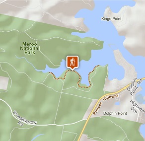
Giriwa walking track
Meroo National Park
Visitor info
All the practical information you need to know about Giriwa walking track.
Track grading
Features of this track
Distance
3km one-way
Time
1 - 2hrs
Quality of markings
Clearly sign posted
Experience required
No experience required
Gradient
Gentle hills
Steps
Occasional steps
Quality of path
Formed track, some obstacles
Getting there and parking
Giriwa walking track is in the northern area of Meroo National Park. To get there:
From Ulladulla:
- Drive south on the Princes Highway and continue through Burrill Lake Village.
- Around 1.5km after crossing the bridge, turn right on to Romney Park Road.
- Follow the signs to Burrill Lake’s East picnic area or Western Arm picnic area, along Lake Road and Burrill Lake Drive.
- You can also take Wheelbarrow Road off the highway, then right on to Lake Road.
From Batemans Bay:
- Head north on the Princes Highway for around 47km.
- Before you reach Burrill Lake, turn left on to Wheelbarrow Road.
- Turn right onto Lake Road after about 1km, then follow the signs to the Burrill Lake’s East picnic area or Western Arm picnic area.
- You can also take Romney Park Road off the highway, then right on to Lake Road.
Road quality
- The unsealed roads to the East picnic area, and in particular to Western Arm picnic area, are not suitable for vehicles with trailers. 4WD vehicles are recommended.
- 2WD vehicles with low clearance should use caution even in dry weather.
- Please take care when turning on to Romney Park Road or Wheelbarrow Road from the busy Princes Highway. Directional signage is not provided from the highway.
- Unsealed roads
Vehicle access
- Most roads require 4WD vehicle
Weather restrictions
- 4WD required in wet weather
Parking
Limited parking is available at Burrill Lake’s East picnic area and Western Arm picnic area.
Facilities
- The nearest public toilets are located at Burrill Lake Lions Park, off Princes Highway, south of the bridge in Burrill Lake Village.
- You’ll find picnic tables at the East and Western Arm picnic areas, at either end of the walk.
Carpark
Maps and downloads
Permitted
Fishing
A current NSW recreational fishing licence is required when fishing in all waters.
Prohibited
- Cycling and horse riding are not permitted on this walking track, but are permitted on public roads and some management trails within Meroo National Park.
- Camping, campfires and generators are not permitted at the East or Western day use areas.
Pets
Pets and domestic animals (other than certified assistance animals) are not permitted. Find out which regional parks allow dog walking and see the pets in parks policy for more information.
Smoking
NSW national parks are no smoking areas.
Operated by
- Ulladulla office
- Monday to Friday, 9am to 4pm.
- 02 4454 9500
- npws.shoalhaven@environment.nsw.gov.au
- Lot 9 Blackburn Industrial Estate, 6 Coller Road Ulladulla NSW 2539
Park info
- in Meroo National Park in the South Coast region
Meroo National Park is always open but may have to close at times due to poor weather or fire danger.