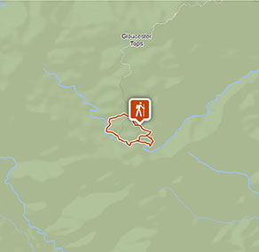
Gloucester Tops circuit
Barrington Tops National Park
Visitor info
All the practical information you need to know about Gloucester Tops circuit.
Track grading
Features of this track
Distance
8km loop
Time
3 - 5hrs
Quality of markings
Clearly sign posted
Experience required
Some bushwalking experience recommended
Gradient
Short steep hills
Steps
Many steps
Quality of path
Rough track, many obstacles
Getting there and parking
Gloucester Tops circuit starts at Gloucester Falls picnic area is in the Gloucester Tops precinct of Barrington Tops National Park. To get there:
- From Bucketts Way, between Gloucester and Stroud.
- Turn into Gloucester Tops Road and continue to Gloucester River
- Continue past the river for approximately 40 minutes
- Take the left fork to Gloucester Tops picnic area
- Turn left here and continue to Gloucester Falls picnic area
Alternatively, the circuit can also be started from:
Road quality
- Unsealed roads
Vehicle access
- 2WD vehicles
Weather restrictions
- All weather
Parking
Parking is available at Gloucester Falls picnic area.
Best times to visit
There are lots of great things waiting for you in Barrington Tops National Park. Here are some of the highlights.
Autumn
Take to the park's walking tracks to make the most of cooler and drier daytime weather.
Spring
Look out for ground orchids and other wildflowers along the Polblue Swamp walking track.
Summer
Look out for the eastern water dragon basking on rocks around the streams.
Facilities
Parking, non-flush toilets and picnic tables are available at Gloucester Falls picnic area.
Maps and downloads
Prohibited
Pets
Pets and domestic animals (other than certified assistance animals) are not permitted. Find out which regional parks allow dog walking and see the pets in parks policy for more information.
Smoking
NSW national parks are no smoking areas.
Operated by
- Gloucester office
- Monday to Friday, 8.30am to 4.30pm.
- 02 6538 5300
- npws.barringtontops@environment.nsw.gov.au
- 59 Church Street, Gloucester NSW 2422
Park info
- in Barrington Tops National Park in the North Coast and Country NSW regions
Barrington Tops National Park is always open but may have to close at times due to poor weather or fire danger.