Somersby Falls picnic area
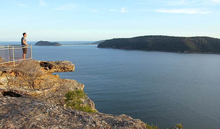
Brisbane Water National Park
Overview
A great place to picnic on the Central Coast, Somersby Falls offers barbecues and picnic tables in a lush rainforest complete with waterfalls and a walking track.
- Type
- Picnic areas
- Accessibility
- Medium
- Entry fees
- Park entry fees apply
- Opening times
9am - 8pm daylight savings time or 5pm at all other times
Somersby Falls picnic area is the perfect place to escape from everyday life. Enjoy your meal amidst lush rainforest that feels a million miles away but in reality is so close to home.
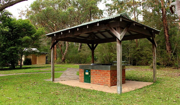
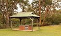
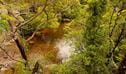
It’s a great place to picnic, with free barbecues and picnic tables and plenty of space to set up your own rug and chairs. Whether you picnic under the shade of tall trees at the far end of the carpark or next to Floods creek before it descends over the cascades, you’re bound to see a bird or two. Make sure you look out for the industrious brush turkeys that might be keen on sharing your lunch.
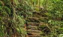
When you’ve enjoyed a tasty barbecue and feel like stretching your legs, try the Somersby Falls walking track. It’s a 500m return walk through rainforest that takes in views of the top and bottom waterfalls. The walk is steep and slippery in places, so keep an eye on the kids as they walk along the track.
Also see:
-
Somersby Falls walking track
Somersby Falls walking track in Brisbane Water National Park runs to the bottom of Somersby Falls, with birdwatching opportunities and a nearby picnic area.
-
Girrakool picnic area
A great spot for a family picnic, Girrakool picnic area has barbecues, lots of green space to run around and a scenic walking track that features Aboriginal engravings.
-
Girrakool loop track
A lovely way to finish a barbecue, the Girrakool loop track is a short and easy walk through bushland, featuring an Aboriginal rock engraving site and scenic waterfalls.
Map
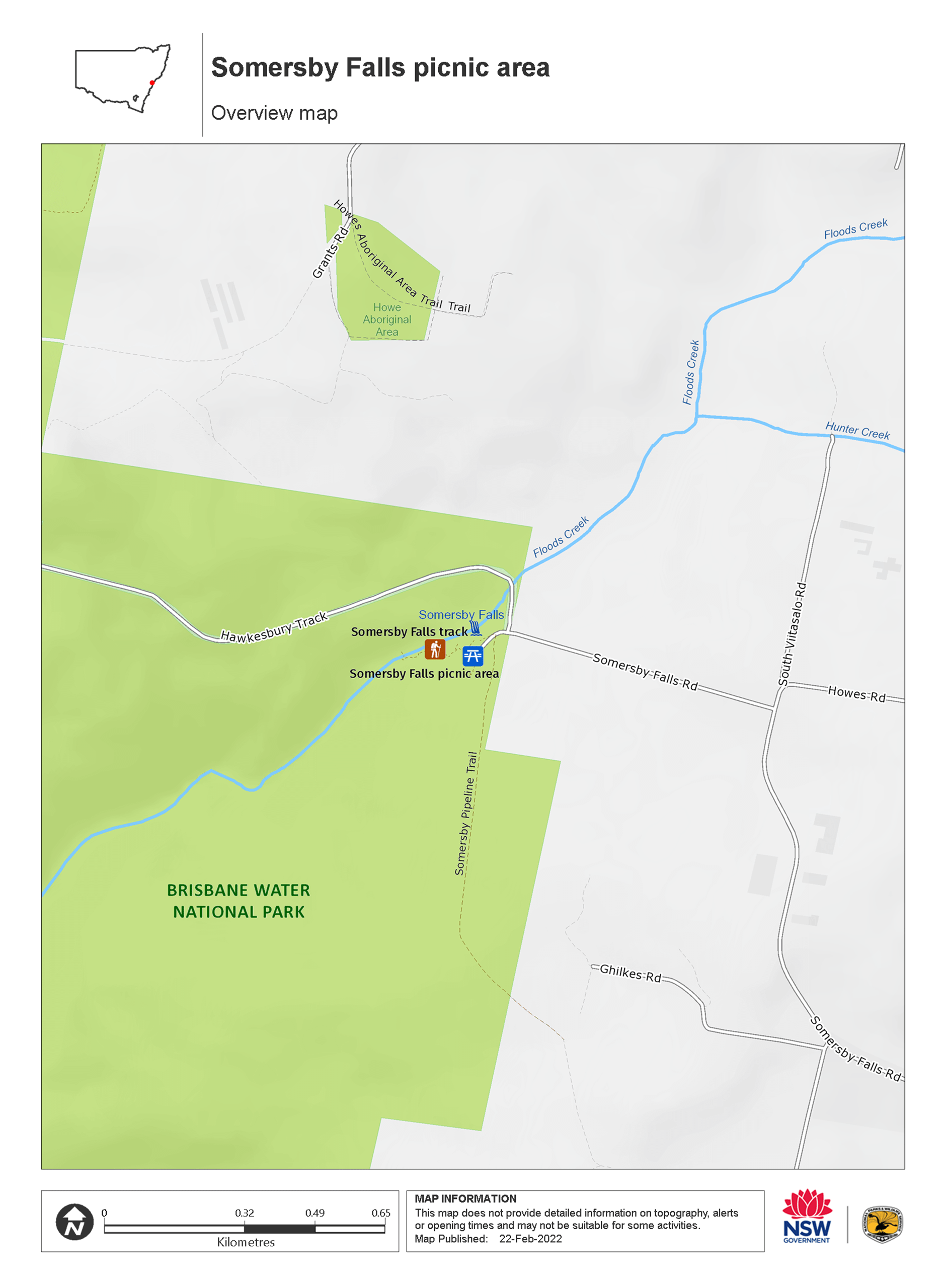
Map legend

Local alerts
For the latest updates on fires, closures and other alerts in this area, see https://www.nationalparks.nsw.gov.au/things-to-do/picnic-areas/somersby-falls-picnic-area/local-alerts
General enquiries
- National Parks Contact Centre
- 7am to 7pm daily
- 1300 072 757 (13000 PARKS) for the cost of a local call within Australia excluding mobiles
- parks.info@environment.nsw.gov.au
Park info
- in Brisbane Water National Park in the Sydney and surrounds region
Two picnic areas in Brisbane Water National Park close in the evening:
- Girrakool picnic area is open 7am to 8pm during daylight savings and is open 7am to 6pm at other times
- Somersby Falls picnic area is open 8am to 8pm during daylight savings and is open 8am to 5pm at other times
Other areas of Brisbane Water National Park will be open at all times, however may have to close at times due to poor weather or fire danger.
-
Park entry fees:
$8 per vehicle per day. The park has pay machines that accept both card and coins, or you can pay via the Park'nPay app.
Other fees:
You will need a permit to hold a wedding or undertake commercial photography within the park.
Buy annual pass.
Visitor info
All the practical information you need to know about the Somersby Falls picnic area.
Getting there and parking
Somersby Falls is located in the northern section of the park, about 5km north of the Girrakool picnic area and the F3.
From Newcastle and Sydney:
- Exit the F3 at the Central Coast Highway towards Gosford
From Gosford:
- Take the Central Coast Highway past Kariong
- Turn onto Wisemans Ferry Road
- Take the second left onto Somersby Falls Road
- The picnic area is at the end of Somersby Falls Road
Road quality
- Sealed roads
Vehicle access
- 2WD vehicles
Weather restrictions
- All weather
Parking
- There are 3 asphalt carparks at Somersby Falls picnic area.
- The carparks open at 9am every day and are locked at 8pm during daylight savings and at 5pm all other times.
- It can be a busy place on the weekend and during summer so parking might be limited.
Facilities
Toilets
There's an accessible toilet that can be reached via a paved stone pathway.
Picnic tables
The picnic tables are set on concrete slabs and are located along stone pathways or relatively flat grassy areas.
Step-free access
- The picnic area is mostly flat
- There's step-free access from the carpark along paved stone pathways.
- At some points there are short, steep ramps where people with reduced mobility may need assistance.
- Step-free outdoor pathways
Maps and downloads
Accessibility
Disability access level - medium
- The picnic area is mostly flat with step-free access from the carpark along paved stone pathways.
- At some points there are short, steep ramps where people with reduced mobility may need assistance.
- There's an accessible toilet
- Picnic tables are accessible and located along stone pathways or relatively flat grassy areas.
- There's a stone pathway that leads to the edge of Floods Creek, just before it descends over the first waterfall with views of the creek.
Prohibited
Camp fires and solid fuel burners
Pets
Pets and domestic animals (other than certified assistance animals) are not permitted. Find out which regional parks allow dog walking and see the pets in parks policy for more information.
Smoking
NSW national parks are no smoking areas.
Learn more
Somersby Falls picnic area is in Brisbane Water National Park. Here are just some of the reasons why this park is special:
A haven for wildlife
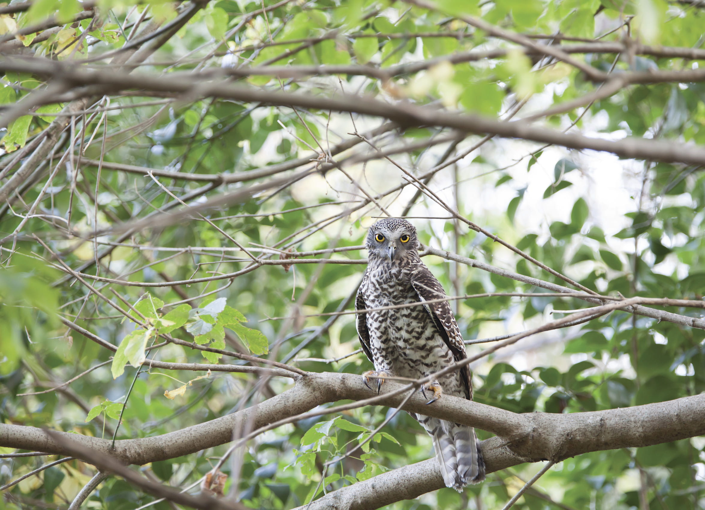
Brisbane Water National Park is home to an incredible 270 native animal species. Keep your eyes peeled for wildlife and bird life such as the threatened spotted tailed quoll, the rare glossy black cockatoo and powerful owl. You might be lucky enough to share a picnic at Girrakool picnic area with a few wallabies who love this peaceful place.
- Girrakool loop track A lovely way to finish a barbecue, the Girrakool loop track is a short and easy walk through bushland, featuring an Aboriginal rock engraving site and scenic waterfalls.
- Great North walk stage 8: Waratah spectacular Panoramic views of Sydney’s northern coastline await you on stage 8 of the Great North walk. The 20km guided tour through Brisbane Water National Park starts at Patonga and ends at Wondabyne Station.
- Great North walk stage 9: Rainforest walk Stage 9 of the Great North walk takes you into the temperate rainforest of Brisbane Water National Park. The 16km guided tour starts at Wondabyne Station and ends at Kariong.
- The Earth’s environment Join The Earth's environment Geography excursion for Stage 2 (Years 3-4) at Brisbane Water National Park, near Gosford. Students will discover how NSW National Parks safeguards over 10 per cent of land in NSW.
- Tommos loop and Rocky Ponds cycling loop Mountain biking enthusiasts will enjoy the challenging Tommos loop and Rocky Ponds cycling loop, a 20km bushland ride taking in scenic Central Coast views.
A wonderland of wildflowers
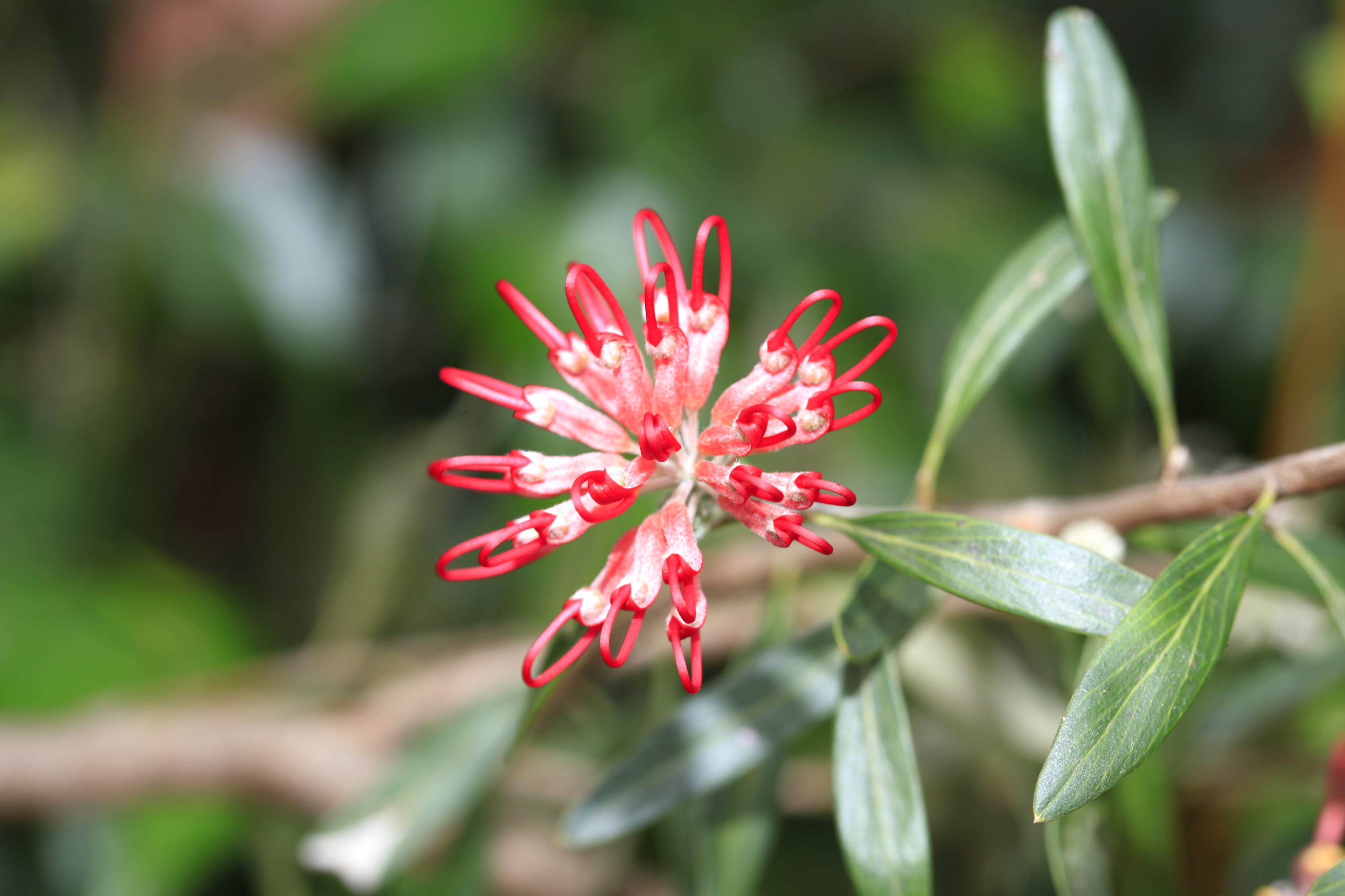
Located 12km from Gosford, the park covers 12,000ha of rugged sandstone country, and boarders the Hawkesbury river, which feeds cascading waterfalls. The landscape is gorgeous all year round, especially from late winter to early spring when it comes alive with colourful wildflowers.
- Great North walk stage 10: Brisbane Water dreaming Complete the Great North walk challenge with the tenth and final leg of the series. You’ll walk 18km from Kariong to Somersby, exploring the serene waterways of Brisbane Water National Park.
- Great North walk stage 8: Waratah spectacular Panoramic views of Sydney’s northern coastline await you on stage 8 of the Great North walk. The 20km guided tour through Brisbane Water National Park starts at Patonga and ends at Wondabyne Station.
- Great North walk stage 9: Rainforest walk Stage 9 of the Great North walk takes you into the temperate rainforest of Brisbane Water National Park. The 16km guided tour starts at Wondabyne Station and ends at Kariong.
- Somersby Falls picnic area A great place to picnic on the Central Coast, Somersby Falls offers barbecues and picnic tables in a lush rainforest complete with waterfalls and a walking track.
- Warrah lookout Warrah lookout, offering scenic views of Broken Bay and the Hawkesbury River, is just a short walk from the carpark. It’s a great place to see Waratahs in season.
Ancient landscapes
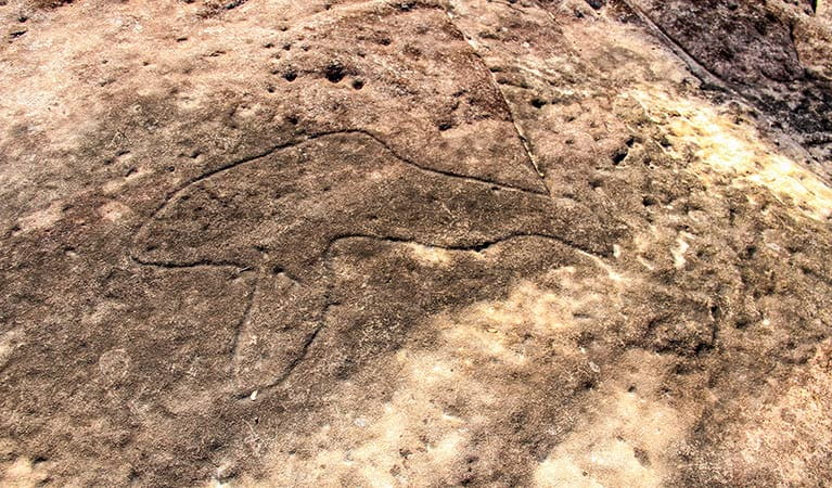
Aboriginal people in the area have a long association with the landscape of Brisbane Water National Park and much evidence of this remains today in the form of rock engravings, foreshore middens and rock paintings. The flat, exposed areas of Hawkesbury sandstone within the park provide an ideal 'canvas' for Aboriginal artists, and there are hundreds of rock engraving sites throughout the park. Aboriginal sites on Hawkesbury sandstone have a distinctive style of engraving which is unique in Australia. The Bulgandry Aboriginal engraving site at Kariong is an excellent example of rock art within the park and is easily accessible.
- Aboriginal culture Bring your students to this unique excursion in Brisbane Water National Park, near Gosford. They’ll experience the park through the eyes of an Aboriginal person on this Stage 2 (Years 3-4) Aboriginal culture Geography excursion.
- Girrakool loop track A lovely way to finish a barbecue, the Girrakool loop track is a short and easy walk through bushland, featuring an Aboriginal rock engraving site and scenic waterfalls.
- The Earth’s environment Join The Earth's environment Geography excursion for Stage 2 (Years 3-4) at Brisbane Water National Park, near Gosford. Students will discover how NSW National Parks safeguards over 10 per cent of land in NSW.
Stretch your legs
Brisbane Water National Park offers great ways to get amongst nature. Why not hop on your mountain bike and get your adrenalin pumping along the Tommos loop and Rocky Ponds cycling route? Or you can wear out your walking shoes along the Girrakool loop walking track. For the more energetic, the park is a hikers delight. Longer treks range from an hour or two to overnight on sections of the Great North walk, which passes through the park on its way from Sydney to Newcastle.
- Girrakool picnic area A great spot for a family picnic, Girrakool picnic area has barbecues, lots of green space to run around and a scenic walking track that features Aboriginal engravings.
- Great North walk - Brisbane Water National Park You’ll find the Wondabyne to Patonga and Patonga to Pearl Beach parts of the iconic Great North walk in Brisbane Water National Park. Take a short walk or overnight hike.
Plants and animals protected in this park
Animals
-
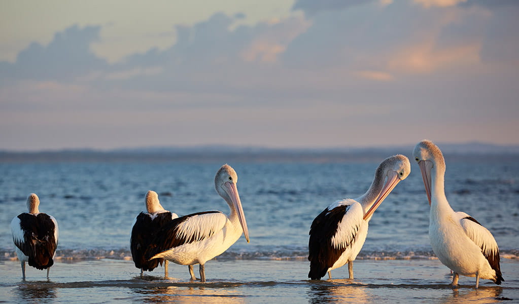
Australian pelican (Pelecanus conspicillatus)
The curious pelican is Australia’s largest flying bird and has the longest bill of any bird in the world. These Australian birds are found throughout Australian waterways and the pelican uses its throat pouch to trawl for fish. Pelicans breed all year round, congregating in large colonies on secluded beaches and islands.
-
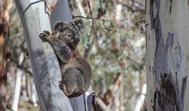
Koala (Phascolarctos cinereus)
One of the most renowned Australian animals, the tree-dwelling marsupial koala can be found in gum tree forests and woodlands across eastern NSW, Victoria and Queensland, as well as in isolated regions in South Australia. With a vice-like grip, this perhaps most iconic but endangered Australian animal lives in tall eucalypts within a home range of several hectares.
-
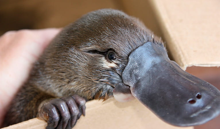
Platypus (Ornithorhynchus anatinus)
One of the most fascinating and unusual Australian animals, the duck-billed platypus, along with the echidna, are the only known monotremes, or egg-laying mammals, in existence. The platypus is generally found in permanent river systems and lakes in southern and eastern NSW and east and west of the Great Dividing Range.
Plants
-
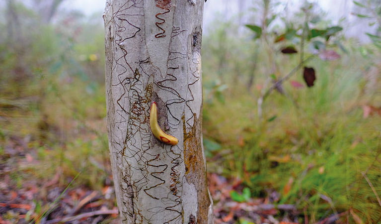
Scribbly gum (Eucalyptus haemastoma)
Easily identifiable Australian native plants, scribbly gum trees are found throughout NSW coastal plains and hills in the Sydney region. The most distinctive features of this eucalypt are the ‘scribbles’ made by moth larva as it tunnels between the layers of bark.
-
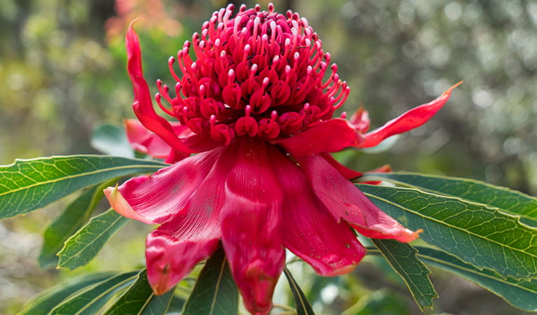
Waratah (Telopea speciosissima)
The beautiful waratah is not only the NSW floral emblem, it's also one of the best-known Australian native plants. This iconic Australian bush flower can be found on sandstone ridges around Sydney, in nearby mountain ranges and on the NSW South Coast. The waratah has a vibrant crimson flowerhead, measuring up to 15cm across, and blossoms in spring.