Red Hands Cave walking track - Blue Mountains National Park
Glenbrook area in Blue Mountains National Park
Overview
Red Hands Cave walking track, in Blue Mountains National Park, offers impressive Aboriginal stencil art with picnicking and birdwatching, near Glenbrook.
- Distance
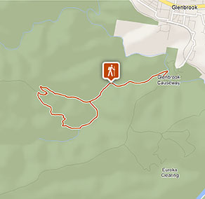
- 8km loop
- Time suggested
- 1hr 30min - 2hrs 30min
- Grade
- Grade 3
- Trip Intention Form
-
It's a good idea to let someone know where you're going. Fill in a trip intention form to send important details about your trip to your emergency contact.
- Personal Locator Beacon
-
Hire a Personal Locator Beacon (PLB) for free at Blue Mountains Heritage Centre in Blackheath.
- Entry fees
- Park entry fees apply
- Opening times
If you’re driving into the Glenbrook area, the gates are open:
- First Sunday in October to first Sunday in April 8.30am to 7pm
- Rest of year 8.30am to 6pm
- What to
bring - Drinking water, hat, sunscreen, compass, gps, topographic map
- Please note
- Please respect this precious site and help protect it by not touching the art and avoiding flash photography.
- For a longer hike, you can walk from the Glenbrook park entry down to the causeway. Make sure you allow extra time for the steep walk there and back (around 3km one-way).
- You can also drive 13km past the park entry to Red Hands carpark, along The Oaks trail and Red Hands trail, for a 1km return walk.
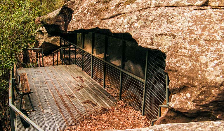
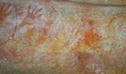
This track has most likely been used by Aboriginal people for thousands of years, and you too can walk in their footsteps. Red Hands Cave walking track, in the Glenbrook area of Blue Mountains National Park, winds through remote bushland to one of the best Aboriginal stencil galleries in the Sydney Basin.
From Glenbrook Causeway, follow the medium-difficulty track along Campfire Creek where you’ll see axe grinding grooves on the water’s edge. Keeping to the right at the track junction, you might see eastern water dragons sunning themselves. Climbing steadily through the gully, you’ll reach the sandstone overhang of Red Hands Cave.
Enjoy a picnic lunch while taking in the unspoilt bush, as rainbow lorikeets and gang gangs chatter above. Retrace your steps or continue the longer loop walk. For a refreshing swim, detour via the swimming holes along Blue Pool walking track.
Take a virtual tour of Red Hands Cave walking track - Blue Mountains National Park captured with Google Street View Trekker.
Also see
-
Red Hands Cave
Red Hands Cave in Blue Mountains National Park is one of the best showcases of Aboriginal rock art in the area. It's reached via Red Hands Cave loop walking track.
-
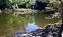
Blue Pool walking track
The family will love a day-trip to Blue Pool walking track. The tranquil bush setting is ideal for swimming and picnicking in Blue Mountains National Park, Glenbrook.
Google Street View Trekker
Using Google Street View Trekker, we've captured imagery across a range of NSW national parks and attractions. Get a bird's eye view of these incredible landscapes before setting off on your own adventure.

Conservation program:
Bush Trackers
Bush Trackers was created to encourage children to engage with the environment in and around the Greater Blue Mountains World Heritage area. This program highlights the natural and cultural splendour of the greater Blue Mountains through education initiatives and bushwalks.
General enquiries
- National Parks Contact Centre
- 7am to 7pm daily
- 1300 072 757 (13000 PARKS) for the cost of a local call within Australia excluding mobiles
- parks.info@environment.nsw.gov.au
Park info
- in the Glenbrook area of Blue Mountains National Park in the Sydney and surrounds region
- From the first Sunday in October to the first Sunday in April: park gates are open 8.30am to 7pm.
- Rest of the year: park gates are open 8.30am to 6pm.
-
$8 per vehicle per day applies at the Bruce Road entrance to the Glenbrook area. You can also pay for your visit via the Park’nPay app.
Buy annual pass
What's nearby:
Things to do (50)
- 4WD touring (2)
- Aboriginal culture (3)
- Adventure sports (1)
- Birdwatching and wildlife encounters (10)
- Cultural heritage (1)
- Cycling (5)
- Environmental appreciation/study (2)
- Historic heritage (5)
- Other experiences (6)
- Photography (2)
- Picnics and barbecues (2)
- Road trips and car/bus tours (1)
- Sightseeing (20)
- Swimming (4)
- Walking (21)
- Waterfalls (4)
- Wildflowers (seasonal) (1)